Employment of Artificial Intelligence and Engineering Data, Helps Improving Maintenance and Decision-making.
Seeking to Prevent Dam Disasters
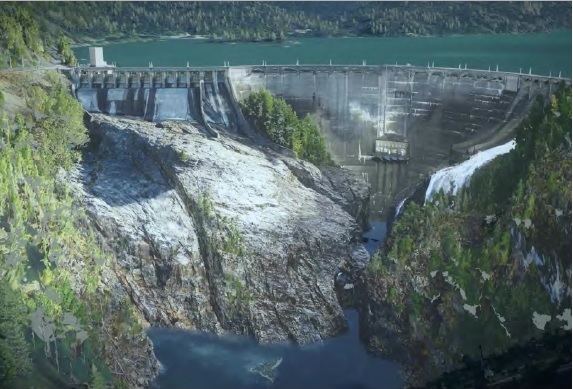
In February 2017, heavy rainfall in northern California overwhelmed the Oroville Dam. Officials discovered that erosion over time caused a crater to form in the main spillway, limiting the amount of water that could be discharged and contributing to Lake Oroville’s rising water level. As a result, water flowed over the previously unused emergency spillway, causing significant ground erosion and damage to the dam. Since the dam faced the possibility of collapse, more than 180,000 people living downstream were evacuated as a precaution. Though Oroville Dam ultimately remained intact, the incident alarmed dam owners and operators across the country and reinforced the need for more effective maintenance to avoid potential disasters. One such owner-operator is Seattle City Light, which conducted major safety reviews to prevent a near-disaster at six of their own facilities, including the Diablo Dam built in 1936 along the Skagit River in north western
Washington. To improve inspection techniques beyond traditional methods on Diablo and gain a more thorough understanding of the aging dam’s current conditions, they wanted to establish virtual inspections that could gather more information while minimizing safety risks on the 160-foothigh facility and lowering inspection costs. Seattle City Light tasked HDR with conducting a survey of the dam and its surroundings with unmanned aerial vehicles. The survey had to include detailed imagery of the dam’s structure, spillways, rock abutments, and concrete arch. Though HDR would collect abundant information on the current state of the dam, they needed a way to arrange and present that data in an intuitive, easily comprehendible fashion, helping operators improve decision making and quickly respond to changing conditions.
Combining a Digital Twin with Machine Learning
HDR determined the most effective way to manage the gathered data and put it to work for more effective inspections was to create a digital twin. A virtual replica of the dam would give the operators another reference point for understanding the state of the facility and provide a new way to maintain awareness of any changes with intuitive visualization of the data. Ideally, the digital twin would be able to incorporate data gathered from traditional ropeaccess inspections, as these manual inspections still provide key perspectives that UAV surveys could miss. Once developed, the digital twin would establish baseline conditions, then become updated as real-world conditions change. However, the project owner wanted to go beyond an accurate reflection of realworld conditions. To meet these goals, HDR needed to completely merge Diablo Dam’s architecture, engineering, and construction data into the digital twin. Additionally, the owner wanted to incorporate artificial intelligence and machine learning into the model. With these capabilities, dam workers could perform predictive analysis and determine how asset and geotechnical conditions would change in the future, such as natural shifting and erosion of the surrounding soil over time. They also wanted to automatically identify cracks and spalls, allowing operators to take corrected action swiftly to prevent them from developing into bigger problems. With this information, the owners could further improve their targeted maintenance scheduling, helping ensure safe operations. HDR sought a digital twin platform that could imbue their reality model with the advanced capabilities needed to provide confidence that Diablo Dam wouldn’t experience a disaster.
Incorporating all Data and Capabilities with Bentley Applications
HDR determined that Context Capture and the Bentley iTwin platform could help them develop a digital twin that would incorporate the analysis and machine learning capabilities needed to ensure the dam’s safety. During a six hour UAV flight, they collected 82 million data points covering all elements of the dam and its surroundings. Then, they used ContextCapture to combine that data with data gathered from rope surveys to create a detailed, surveygrade reality mesh of the area. In the process, the data helped engineers identify geologic features that would be difficult to access manually, which would help improve the accuracy of future assessments. The team then used the iTwin platform to create a detailed digital twin of the dam and its surroundings. All project information, no matter the discipline, was incorporated into the federated model. Due to the open nature of the iTwin platform, HDR incorporated their preferred artificial intelligence and machine learning technology. As a result, the digital twin can automatically detect cracks and spalls, as well as differentiate them from harmless shadows, discoloration, and algae growth. With predictive analytics incorporated into the digital twin, dam engineers can compare data of a given year against that of other years. By observing changes in the surroundings over time, such as soil shifts, they can predict that the structure will continue to shift at a similar rate over time, barring unusual seismic activity.
Taking Corrective Action Faster Integrating all information about the state of the dam’s assets, structure, and surroundings into a digital twin has greatly improved access to and understanding of project data. Combining the digital model, which has survey-grade accuracy, with traditional on – site rope inspections gives inspectors much more detailed insight into current conditions. HDR estimates the initial reality capture for the digital twin was just a quarter of the cost of traditional surveys. With accuracy within two centimeters, dam operators can detect much smaller anomalies and take corrective action before they grow into larger problems. Additionally, numerous operators can keep track of the dam’s current conditions from their offices or remote workstations, which improves safety as well as convenience. Now, all dam stakeholders can share information quickly, which provides a single source of truth and speeds decision-making. By applying artificial intelligence and machine learning, the owners can now automatically identify areas of concrete with anomalies, then differentiate between cracks and spalls to better determine the corrective action needed and prevent problems from becoming worse. At the same time, filtering out shadows and discoloration prevents unneeded maintenance activities. Dam operators plan to add more capabilities to the digital twin such as additional hydraulic engineering, uplift analysis, and change and anomaly detection to further improve the dam’s ongoing safety and provide additional sources of ROI


